
Trekking Northern Pakistan
- Jun 18, 2025
- 15 min read
Updated: Jun 19, 2025

Our guide poses at the foot of Nanga Parbat, the world's ninth-highest mountain.
Six months of planning this trip and I’m finally on my way to Pakistan. In 36 hours we will be taking in the jagged peaks of the Himalayas from the vast expanses of Hunza Valley. This long-planned trip is timed both perfectly and disastrously. On one hand, I’m taking two weeks off - a much needed break - and the time off is very much welcome. On the other hand, I’m headed straight to contested Kashmir, one of the world’s most divisive geopolitical fault lines. India and Pakistan are just emerging from a serious conflict which brought both nuclear-armed nations to the brink of all-out war. Delhi and Islamabad only recently agreed to a ceasefire agreement, which appears to be holding but could be broken at any moment, and the world looks on uneasily, knowing that the peace could easily break, should either side ramp up nationalistic rhetoric to shore up political support.
As I ponder the trip on the flight from Istanbul to Islamabad, I can’t stop thinking: what the hell am I doing? Is this insanity? Will this trip be an adventurous, adrenaline-filled two weeks, or more draining than rewarding? I can only wait and find out: my fate is entirely up to the travel gods.
Day 1. Sunrise in Islamabad. It’s 4 in the morning but the day is already bright. The airport is open and airy, full of chirping birds. I feel disoriented so do some quick reading on the basics: the exchange rate ($1 = 280 rupees), basic Urdu (thank you = shukria), recent politics (Benazir Bhutto, Pervez Musharraf, Shehbaz Sharif), and how they got the nuke (the covert program was set up by Benazir Bhutto’s father when he was in charge, and led by one Dr. AQ Khan. There’s a fascinating story here about international subterfuge, clandestine operations and black market smuggling networks at the height of the Cold War, which I won't get into now).

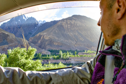
The flight to the northern city of Gilgit is a safari in the sky. Looking out of the plane, we are at eye level with some of the world’s highest peaks, and the propeller of our small plane is making brush strokes in the whisky cumulus clouds. Nanga Parbat, the world’s ninth highest peak, looks back at us indifferently, with her snow covered peaks and deep crevasses. We land in what feels like a a frontier town - chaotically busy in some areas, dusty and barren for other large stretches of road - and choose a nice hotel for some rest after the red eye flight. It is a compound. Several heavy gates, a check point with armed guards, and concrete blocks in zig zag formation slow our arrival. We x-ray our bags and arrive at reception. We are welcomed with extraordinary attentiveness; we drop our bags in the room and feast on lunch with a view.
Day 2. We leave early for Raikot bridge, from which we will hire a jeep to get up the mountain and start our trek. The road there is all mountainous desert.

Intricately decorated trucks bursting with color stand in stark contrast to the browns and beiges of the surrounding landscape and orient us firmly in South-Central Asia.
In Raikot we are greeted by a local policeman, who asks for our passports for registration. His simple room doubles as an office. It has a small single bed, a fan, and a copy of the Quran in a plastic bag hanging from the wall (lest he should put the holy book on the ground). Once he has been satisfied of our itinerary, we are ushered into a jeep to begin the vertiginous hour and a half climb up the mountain. I have been on some sketchy rides before but this is unlike anything I have ever experienced. We rumble along an extremely rocky road carved out of the mountainside, which has been built through the sheer force of human will. It is a marvel of human engineering and I wonder how many laborers died building it. Looking out the window, there is nothing but an empty void, and as I look out I know we are just a few meters from falling to our deaths. But I trust the driver: He is an expert with the jeep and knows the road by heart, like a free solo climber who has memorized every hand hold and foot placement for a six hour climb.


Car trouble on the tight and narrow roads up to the trailhead for Fairy Meadows make for an exhilarating experience.
After a long and bumpy ride, we arrive at the trailhead for Fairy Meadows. It’s a two hour hike and we already feel the thin air testing our lungs. On the way we run into a skinny and approachable 20 year old named Rustum. He shows us a shortcut to the top and takes our picture. We agree to stay in his hotel.


The hike to Nanga Parbat and the view from Fairy Meadows.
Fairy Meadows is a green valley of wooden huts and hotels catering to (mostly domestic Lahori) tourists. It is surrounded by mountain peaks on all sides and from our room we can see the icy and powdered behemoth of Nanga Parbat. It’s already been a long day so we decide to go to bed early to get some rest for the trek to base camp tomorrow. But my stomach is upset - must have been something I ate - and I spend a long, sleepless night running to the toilet. Around sunrise I manage to fall into exhausted slumber.
Day 3. I’ve rehydrated enough and managed to sleep a few hours so we hire a local guide to show us the way to base camp, and by 9am we are on our way. We pick our way uphill through pine forests and lush meadows. After several hours’ ascent, we rest at a steep path which leads towards the edge of a glacier oozing out of Nanga Parbat.

Our guide pauses to recite a prayer (bismillah irrahman irraheem…) Few times have I heard this prayer outside of a mosque, but to hear it in the wild like this alerts me to potential danger ahead. We begin the rocky descent toward the glacier, a giant living thing that creaks and groans and shifts. We pause to take a picture, but our guide, well ahead of us, beckons us to hurry. “Slide” he says, pointing to our feet, at what appears to be a recent landslide. Best to avoid staying in one spot for too long.
We eventually reach a flat meadow - base camp one of four - where we stop to take a picture of a yak grazing in the distance. The large beast fakes a charge at us for a few meters, stomping his hoof in a clear warning to stay away. We politely acquiesce and continue the steep climb up the mountain. As we pause for breath and look back, we look down to see him locking horns and battling another yak. Despite the distance, we can hear the two beasts slamming their heads into each other, like a crack of lightning, and we shudder to think what the yak could have done if it had directed its territorial anger at us.
After a steep climb we reach base camp two at 3,500 meters. In a small stone refuge, our guide whips up ramen noodles and milk chai in a small cauldron, before showing us the nearby memorial of a German hiker who had died in a landslide in 2008. As we contemplate this unfortunate soul, it starts to hail and we hear thunder rumbling in the distance. The jagged peaks are submerged in opaque grey mist. Our guide offers us two options to get back to a juncture in the trail. But the thunder cracks again, this time closer. He jumps, and begins running down the hill. We follow, charging down the slope. Hail starts to soak us through our clothes and sharp air fills our lungs. We cackle maniacally from nature’s cold indifference, relishing the adventure which we came to seek out.

Descending towards the glacier.
Every hour or so we stop at a small hut to sip chai, warm up and chat with the locals. The men and boys come up here to run these remote mountain outposts for six months out of the year. They are several days' walk from their home villages, where they return in the winter. Their existence here seems lonely and harsh. They tell us about the local mountain lore and why Nanga Parbat is known as the killer mountain. It’s notoriously technical and hazardous, deadlier than Everest with, until recently, a 30% death rate. We get back to Fairy Meadows wet, cold, and grateful. It is a good night’s sleep.
Day 4 and 5. We wake early in the morning, say goodbye to Rustum and his brother, and hike quickly back down to the jeeps. We find our driver Naim again and embrace him. Another bumpy road down and we are back to the parking lot. We get to our car - boiling and covered in dust - and drive back to Gilgit for some rest and recovery.
Day 6. Today’s objective is to reach Khunjerab pass, site of the China-Pakistan border. At 4,300 meters, it is the world’s highest border crossing, and can only be reached via the Karakoram Highway (KKH), its highest paved road.
We wind our way up, slowly gaining altitude surrounded on all sides by the desolate and forbidding peaks, shrouded in misty clouds. The landscapes in which we are driving through simply defy exaggeration. Our excellent guidebook Trekking the Hindu Kush and Karakoram in Northern Pakistan helpfully informs us: “the world’s greatest mountain chains - the Karakoram, the Himalaya, the Hindu Kush and the Pamir radiate out of northern Pakistan like spokes on a wheel. In no other part of the world is there such a large number of high mountains in such a confined space.” Indeed, Pakistan alone has over 118 peaks over 7,000 meters and hosts five of the world’s fourteen 8,000 meterers. Today’s drive gives us privileged access to these landscapes.
On the way we stop at Husseini bridge, a wooden suspension bridge strung over a canyon linking two remote villages. There is a wide step between each wooden plank on the bridge - something out of an Indiana Jones movie - and as you look down to place your feet you see only a fast-moving and raging glacial river ready to brace your fall. The bridge crossing is a rewarding thrill in itself.

We stop to speak to a few villagers near the bridge here in Hunza. Their features - grey and blueish eyes, higher cheekbones, almond-shaped eyes - already seem different from the people in Gilgit. One man we speak to explains that it is because of their Tajik heritage, and traces his provenance all the way back to Alexander the Great. I’m a bit skeptical, and our guidebook seems to confirm the legend of Alexander’s soldiers, “which passed through Pakistan in 325 BC, settling in the valley with their Persian wives and founding the villages of Altit, Baltit, and Ganesh” as “a pretty story, but unfounded.”
Regardless, the noticeable change in physical features - a rapid change in human geography given the mere 60 minute drive from Gilgit - is a testament to the rich cultural heritage of the area. These narrow mountain valleys “were so cut off that, until recently, they each formed a separate little kingdom, ruled by a raja or mir, each speaking its own isolated language.” The KKH, after all, wasn’t built until 1979, connecting this region to the rest of Pakistan and the world.
From at least 6,000 years ago, small communities of hunters, herders, traders and pilgrims began crossing the Hunza Valley, which later became an important part of the Silk Road relaying India, China, and the Greek (and later, Roman) empires. Despite the relatively isolated nature of the region, this most central point of the Eurasian landmass has always acted as an important crossroads, which saw merchant caravans traveling from Kabul to Kashgar and other Silk Road outposts. This is also where the epic drama of the Great Game unfolded: a sweeping story of espionage and intrigue which pitted Britain against Russia for strategic control of Central Asia in the 19th century. If we fast forward to the Russian invasion of Afghanistan in 1979 and then to the American invasion in the early 2000s, perhaps nowhere else does the platitude “history repeats” hold so true.
The women in Hunza also seem more open and friendly. In Gilgit, we hardly saw any women in the street - and the few women that we did see averted our gaze. In this stretch of the KKH, women seemed on more equal footing with men and met our salaam with gracious smiles. Again from the guidebook: “in the 1820s the mir was converted to the Ismaili sect of Islam and brought most of his subjects with him to the new faith. The openness and friendliness of the Hunzakuts is in part a result of this, as Ismailis are freer in their outlook than other Muslims - as far back as 1904, for example, the then Aga Khan decreed that women should come out of seclusion and be educated.”
Today, the current Aga Khan is the 50th hereditary imam, or successor and direct descendent of, Ismail. He lives in (a presumably opulent palace in) Portugal, but takes a keen philanthropic interest in his community of adherents, developing the area and establishing funds for the preservation of its cultural heritage. The precise details of the sect and its nuances evade me, but for further understanding I recommend Tamim Ansary’s Destiny Disrupted: a History of the World through Islamic Eyes. It is an authoritative, fascinating and highly readable account of all the various empires, schisms, and strains, from the founding of Islam to present day.
We continue to snake up towards Khunjerab Pass. We maneuver under and around towering cliffs of stone. There are often huge rocks on the road, reminding us of the frequent landslides and rock falls, and the landscapes are of mythical proportions, evoking images of the Greek ancestors of modern lore.
After four hours of driving we arrive at the border with China. We feel a sudden surge of victory, and it’s clear we’re not the only ones. A group of Pakistani visitors starts blasting music from a boombox. In a spontaneous moment of joy and celebration we all break out in song and dance. At over 4,600 meters we are at the highest border crossing in the world, higher even than the top of Mont Blanc.


Just across the border, the mountain pass descends into the plains of China: cities and provinces like Xinjiang, Kashgar and Urumqi. To the ancient Chinese, who saw themselves as the civilized Middle Kingdom, this area was the Wild West, where equestrian maurauders pillaged and terrorized across the flat plains stretching from Hungary to Mongolia. These are the great steppes which birthed the likes of Attila the Hun, Genghis Khan, and Timurlane, those titans of world history who didn’t leave a written record. Indeed, most of what we know about these great societies is only through the records of settled empires, who defined themselves directly in opposition to these nomadic “barbarians”. I’m getting sidetracked here, but the history nerd in me is thrilled to be standing at these crossroads.


The drive back is equally rewarding. The clouds that had obscured our view on the way up suddenly part, and we are even more stunned than on the way to Khunjerab. Some mountain tops are so massive, and appear so high above the clouds, that they seem to be separate celestial bodies floating in the sky. Several times I simply let my jaw drop while my mind struggles to comprehend the scale of what I am looking at.
Day 7 and 8. Over the next two days we use Karimabad as a base for exploring Altit and Baltit forts and hiking to Eagle’s Nest, which provides a vantage point over both forts and the entire Hunza Valley.

Baltit Fort, built in the 8th century, was the palace for the mirs of Hunza and dominates the valley below.
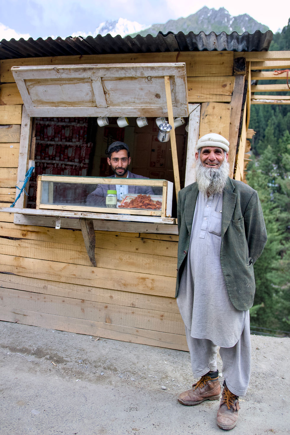
The city is aptly named as we run into several Karims throughout the day. The first is an affable dried fruit seller who offers my friend a hat for his birthday. His eyes - again that light grey which legend traces back to the greatest of Macedonian generals - exude kindness and generosity, and he makes an irresistible subject for a portrait.


(1) Karim from Karimabad, number one. (2) A guard at Baltit fort dresses in traditional Hunza attire and boasts facial hair that took him over 20 years to grow.
We encounter the second Karim after our hike up to Eagle’s nest. After enjoying the view of several 8,000 meter peaks, we descend the long hill down through little green villages back towards town. We give the universal thumbs up sign to hitchhike down. He drives a red tractor and is hauling gravel from the mountain to make concrete. We hop on the back and exchange pleasantries. Karim takes us to his village to meet his father and offers us tea. One of his father’s friends recounts being a prisoner, captured by the Indians during the 1971 Indo-Pakistani war.

Karim from Karimabad number two let us hitch a ride down the mountain on his tractor.
Our third Karim appears when, exhausted and weary, we return to our hotel to discover our car battery has run out. A mustachioed mechanic, Karim three takes it upon himself to jump start our car and drives us to the next town over to help us fix everything, even paying for the repairs while refusing reimbursement. We insist forcefully for him to accept our offer of a tip. The three Karims in Karimabad, it appears, were our ever watchful guardian angels.
Pakistanis have been nothing but kind and and generous to us, and it’s unfortunate that the country has such a bad reputation: the people we meet have shown is an extraordinary humanity and hospitality that isn’t easy to forget, and they are eager to change perceptions about their country.
Day 9. The next day is rainy and we use it to drive to Minapin, the starting point for our next trek, and rest in a little guesthouse near the trailhead. It’s a good time to drink tea and catch up on reading.
Day 10. Another day, another trek. This one seems more challenging than Eagle’s Nest and Nanga Parbat base camp. The climb is steep and challenging and we feel weak due to ongoing indigestion. At this point, the trip is beginning to wear us down. Two weeks of fatigue, dust, heat, and oily, spicy cuisine have affected our bellies and thus our minds. We brave the ascent and make a few jokes about hot air balloons rising up a mountain, but it’s clear that neither of us are in great shape. After a steep vertical climb we are grateful to reach Hapakun, where we pay for a tent and sleeping bag, skip dinner, and fall asleep early.

Day 11. Feeling slightly better, we continue up the mountain. We know there is a fantastic view up top but we don’t know what to expect. After crossing over a ridge, two gigantic white mountains reveal themselves to us proudly and majestically. These are Rakaposhi (7,788 m) and Diran peaks (7,266 m). It is truly one of the most stunning mountains I’ve ever seen: wind whips snow from the top of the mountains, obfuscating the line between elements as snow evaporates into the clouds. From this distance it is a calming site but I know that at the peak it must be tumultuous and angry. I respect - but do not envy - these high altitude mountaineers, who risk life and limb for personal satisfaction and glory.

Rakaposhi rises in the distance above base camp.
Day 12. We push on, taking a day trip to Naltar Valley. This is the greenest part of Pakistan we have yet seen. It is covered in aromatic pine forests and reminds me of Chamonix or other parts of alpine Europe. We hire a jeep to take us to Satrangi and Blue Lakes, gorgeous green and blue bodies of water which reflect the mountains above them. The colors and smells of this alpine environment suddenly make me crave the mountains of Europe and I feel again a surge of gratefulness for being where I’m from.


Naltar valley boasts some of the greenest landscapes in northern Pakistan and a stroll through its alpine forests strangely and suddenly evoked memories of a summer in Chamonix.
Day 13. We fly back to Islamabad. Today is Eid ul Adha, a Muslim holiday. The airport is eerily empty and we struggle to find a taxi in the 40c (104f) degree heat. We pack six into a run-down taxi with no seatbelts or rear view mirrors and speed through dirty and polluted Rawalpindi. Goats and cows are assembled on the street, tied together, dumbly unaware of the fate that awaits them. We had purposefully booked an apartment in a fancy area of Islamabad, hoping to avoid having to see the ritual slaughter of these animals in the street. We check in and are happy to see we’ve avoided the worst. We spend a buoyant afternoon visiting an excellent bookshop with lots of great books on geopolitics and history, and we eat what seems like our first clean and fresh meal in 10 days. We feel re-energized and positive.
Inspired by the interesting books we discuss on the walk home Edward Said’s Orientalism, a famous critique of the Western “orientalist” and “exoticizing” gaze on the Muslim and Arab world. We had gotten the gist but admit to each other that we didn’t take away much from the notoriously dense and unreadable narrative. And on that note, we return home to see, just behind our apartment, a group of long-bearded, knife-wielding men, their long robes covered in blood. They are hacking away at goat carcasses in the driveway, the blood runs thick from the entrails on the streets. The stench is nauseating. We enter our apartment and put our heads down. Behind us we hear chop… chop… chop… the incessant rhythm of a butcher’s labor. We put on a movie to drown out the noise. The noise continues for hours unabated. My mind turns dark and is stormy with prejudice and judgement. I find myself suddenly eager to leave.
This is new for me. How is that I, the Intrepid World Traveler, a student of world cultures, the amateur of human geography, can be guilty of such intolerance? Am I guilty myself somehow of orientalism, of gazing condescendingly on a culture I do not understand? Have the weeks of exhaustion and bad diet simply shortened my fuse? Or am I just getting older and less tolerant of “cultural relativism” and now, more rigid in my later years, becoming more of an absolutist? I never encountered these thoughts in my other travels, whether in Indonesia or Morocco or Turkey. Have I somehow reached the limits of patience? Cultures, like relationships, are nuanced and complex, and they are hard to draw definitive conclusions from. Pakistan has left me both fulfilled and drained, and I've squeezed every ounce from it that I can. I am as disoriented as the day I came, and even though I leave the country with a bit more knowledge on the region, I am only more aware of how much I don't know.
What are my final thoughts? This will take time to digest. Only the travel gods will know…


Comments